Plane-Wave Analysis of Solar Acoustic-Gravity Waves: a (Slightly) New Approach
Richard S. Bogart & Luiz A. D. Sá,
Center for Space Science & Astrophysics, Stanford Univerity
Thomas L. Duvall, Jr.
NASA Goddard Space Flight Center
Laboratory for Astronomy and Solar Physics
Deborah Haber & Juri Toomre
Joint Institute for Laboratory Astrophysics, University of Colorado
Frank Hill
National Solar Observatory, National Optical Astronomy Observatories
Table of contents
Abstract
Plane-wave decomposition of acoustic-gravity wave effects observed in the
photosphere provides a computationally efficient technique for probing the
structure of the upper convective zone and boundary, where the flat-sun
approximation is reasonably accurate. We describe the technique to be
used for systematic plane-wave analysis of MDI data as part of the SOI
data analysis pipeline, and the SOI analysis plan. We present estimates
of sensitivity and discuss the effects of using different planar mappings.
The technique is compared with previous approaches to the 3-dimensional
plane-wave problem.
Introduction
Although the Sun is not flat, it is comparatively large. At least at
some scale, analysis of local motions in the upper part of the convective
envelope can be performed in plane geometry. In particular, the Sun's
internal acoustic-gravity waves observed in the photosphere can be
analyzed as if they were plane waves, even though they are in fact
constrained to the eigenmode solutions of the wave equation in a nearly
spherical cavity. Analysis of the 5-minute oscillations did originally
proceed (largely for observational reasons) as a two-dimensional
plane-wave problem, before and for some time after the recognition
of these oscillations as global modes. In this approach, only waves
propagating in one direction along the solar surface (parallel to an
observing slit) were detected. With the advent of imaging Doppler
detectors, helioseismology has become almost exclusively spherical.
It has been demonstrated that a full three-dimensional plane-wave analysis
of solar oscillations can be readily performed and the results inverted
to yield at least plausible inferences about the dynamics of the upper
convective envelope (Hill, 1988).
In a plane geometry, the dynamical equations governing acoustic-gravity
waves can be written very simply. It is quite straightforward to show
that a motion relative to the observer of the field
in which the waves propagate results in
an apparent frequency shift proportional to the dot product of the velocity
vector and the horizontal wave-number vector
v(x,y,z) · k(x,y,z),
suitably averaged in depth z for each eigenmode. Variations in
sound speed produce frequency shifts proportional to the square of the
wave number.
The first problem to be overcome in plane-wave analysis of solar waves
is the mapping of the observed surface to a plane. It is assumed
that the relative positions of any two points fixed on the Sun
(in whatever heliographic coordinate system we choose) remain the same.
The mapping can be done trivially by not ``mapping'' at all,
i.e. by using the nearly orthographic projection of a spherical
surface onto a plane from a point almost infinitely far away.
It is pretty clear however that this is not the best mapping to use,
or even a particularly good one, since (a) the scale changes depending on
the location of the observed region with respect to disc center, and (b)
the outer layers of the Sun are known to rotate at roughly 2 km/sec
and this will introduce a basic frequency shift for all modes. The
mapping that has found favor so far is Postel's azimuthal equidistant
projection, in which the geodesics passing through a selected point
are mapped as straight lines with equal intervals representing equal
distances on the surface. (For a discussion of this and other common
map projections, see Richardus & Adler 1972.)
We have experimented with about a dozen
standard cartographic mappings, comparing the distortions
in the shapes of the power spectra
as larger areas of the sphere are mapped. We find that the projection
that minimizes distortions in the region of interest is Lambert's azimuthal
equivalent (equal area) projection, but the differences among most of the
reasonable choices, including Postel's, are slight. For purposes of
comparison with other approaches, we have adopted Postel's projection
for this work.
The mapping from heliographic coordinates implicitly involves tracking
of the solar surface, at least to the extent that the heliographic
coordinate system reflects the mean motion of the surface. Since the
photosphere rotates differentially, the question of which coordinates to
use is not trivial. There are three basic choices: to assume rigid body
rotation (using the Carrington coordinates for example); to assume uniform
rotation of the field of interest, but at a rate appropriate to some
representative latitude within the field; or to track each latitude
independently, using a shearing coordinate system. While
developing and validatiing the analysis techniques, we have so far
restricted our attention to datasets of no more than a few days in length,
so the differential shear over the comparatively small fields of view is
not a matter of concern. We have however chosen to use as the base rate
for tracking the differential rotation rate suitable to the center of the
selected field. This means that the Carrington coordinates describing
the field are only applicable at one instant. We describe the field by
the Carrington coordinates of its center at the (virtual) time of crossing
of the central meridian observed from Earth.
As the data are mapped, they are also apodized in a circularly symmetric
pattern, in order to eliminate the effects of non-isotropic higher
spatial frequencies in the data resulting from our use of a square field.
The time series of mapped and apodized data is then Fourier transformed
in three dimensions and the three-dimensional k-w power
spectrum is computed by standard methods. It is the ease and speed
of this calculation that provides the impetus for plane-wave analysis.
The eigenmodes organize the power spectrum into surfaces of local peak
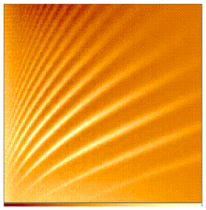
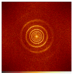
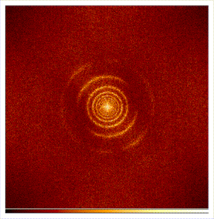
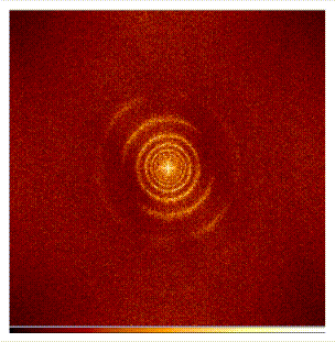
power of the approximate form w ~ sqrt (k). Two cuts through
a typical power spectrum are shown in Fig. 1. The first
is equivalent to the plane ky = 0, corresponding to a standard one-dimensional kw (or lv) diagram. The second
is a cut through the space at a particular temporal frequency. The
characteristic rings of power representing successive
eigenmodes of decreasing vertical order with increasing k have
inspired the name ``Ring Diagram Analysis'' to this branch of heliseismology.
Up to this point, with the exception of the choice of mapping and tracking,
the analysis is quite standard. The real opportunity for efficiency (and
different systematic errors) comes in the parametrization of the
distortions of the individual eigenmode surfaces. Because the first-order
effect due to advection is to change the frequency of a given mode by an
amount proportional to
v·k = vkcos(0),
where 0 is
the angle between the k vector and the direction of motion,
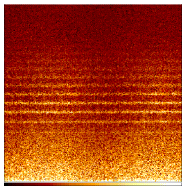
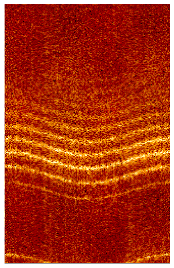
we ``unwrap'' the surface for a given value of k, that is, we make
a cylindrical cut through the power spectrum parallel to the w axis,
giving P(w,0). The peaks in this two-dimensional
power spectrum are a series of nearly straight lines at the eigenfrequencies,
with a slight sinusoidal dependence on 0.
(See Fig. 2 and Fig. 3). We
determine the frequency wn(0)
for each
eigenmode and then Fourier analyze it. The amplitude and phase of the
first order term in the Fourier expansion then give the magnitude and
direction, respectively, of the fluid motion. Higher-order terms of
course provide information on 2nd-order effects of sound speed variation.
This analysis is performed for each clearly identifiable mode and repeated
for numerous values of k so that the distortion parameters can be
built up as functions of radial order n and horizontal wavenumber
k for inversion.
Of course the waves are quantized only in the vertical direction
by the trapping cavity under our plane-wave assumption, and are continuous
in k; the choice of how thick to make the cylindrical cuts and how
to space them is arbitrary and essentially dictated by the data resolution.
But for spherical-harmonic analysis of oscillations of high spatial frequency
in the horizontal direction it is generally impossible to isolate individual
eigenmodes by degree and azimuthal order as well.
In order to verify and calibrate the present technique we have sought first,
to compare the results obtained on a particular data set with those obtained
by the original technique independently, and second, to measure the response
to known displacements in the data. For this purpose we have used a sample
data set from the High-L Helioseismometer at the National Solar Observatory.
The data consists of 1024*1024 pixel images taken once per minute in the Ca K
line over a period of four observing days from June 22 through June 25, 1993.
This dataset is particularly advantageous because it has
the same scale and format as the full-disc data we expect in future, and
because intensity images are easy to track visually for extended
periods, allowing us to verify the tracking involved in data mapping.
We have independently analyzed the same selections from the test dataset
using the methods described in
Haber et al. (1995)
and those described here. We have used and compared independent programs
to perform all preliminary stages of the analysis from mapping through
determination of the power spectrum, and then have used independent methods
of mode identification and parametrization applied to the same power spectra.
The actual preliminary results are presented
elsewhere (Bogart et al., 1995). Here
we focus only on the validation tests.
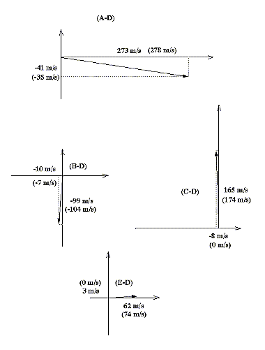
The primary validation test has been to take a data set consisting of
a single day's data (that of June 22, 1993), select a particular region,
and then to track the region at each of several different rates in various
directions. The tracking rates were not known to those performing the
mode parametrizations. Our assumption is that without performing an
inversion and without knowing details of the real velocity profile with
depth, it must still be true that a uniform translation of the observer
will raise or lower the frequencies by a fixed amount for each
mode, so that the differences between the inferred vector
velocities in two cases for any mode should be the same as the differences
in the two artificially generated field velocities. The results from
the new method are shown in Figure 5, and those from
both methods are given in Table 1. It is clear
that both methods generally yield roughly similar results and match
the expected velocity differences within about 20 m/s.
We consider this a very promising confirmation of the essential
power and accuracy of the technique. There are a few noticeable exceptions:
The ring diagram technique seriously underestimated the meridional
velocity component in one case (C), and both were far from the expected
zonal component in case (A). Since this case involved changes in the
higher order components in the differential rotation law, this could
perhaps expose an error in the tracking program, but we do not have
an explanation at this time. More work remains to be done to
explore any possible systematic differences between the two methods.
It is also of course essential to approach the problem of inversion
for the vertical structure of the velocity field as well as 2nd-order
effects of sound-speed variations.
The Solar Oscillations Investigation (SOI) on SOHO will afford an outstanding
opportunity for plane-wave analysis of acoustic modes, with a capability of
uninterrupted high-resolution observations continued for full solar
rotations and regular daily sampling for extended periods. We plan to
conduct the analysis with data processing along the lines outlined here
during the Dynamics Program (two months of continuous full-disc observations
and one month of continuous high-resolution observations), and during any
other time when essentially continuous full-disc and/or
high-resolution velocity and/or intensity images are available for a
minimum of 3 days.
We will extract maps of each calibrated observable centered on a set of
selection points. The mapped subimages for the full-disc field will
have an extent of 30 degrees, i.e. extend at least 15 degrees from the
selection center in all directions. The mapped regions will be tracked
at a constant rotation rate applicable to the latitude of
the selection center and referred to the heliographic coordinates of the
center at the time of its meridian crossing as observed from Earth.
The selection centers from the full-disc data will be located at
approximately 15 degree spacings
extending as far as ±60 degrees latitude. (The size of the fields will
of course be smaller and their
spacing correspondingly closer for the high-resolution fields.)
For each time series of tracked regions at a given selection center, we will
compute the spatial-temporal power spectra for time samples of about 3 days'
(4096 minutes) duration; for a longer data series, multiple power spectra
will be computed so that the whole data series is sampled. These power
spectra will be analyzed using the procedure described in this note to
construct tables of 1st- and probably 2nd-order coefficients in the azimuthal
expansion of frequency shifts as functions of radial order and horizontal
wave number up to the spatial Nyquist frequency. We believe that the
frequency-shift coefficients can be used in that form as the starting point
for inversions, but this remains to be established.
References
- Bogart R. S., Sá, L., Haber, D.,
& Hill, F. 1995.
``Preliminary Results from Plane-Wave Analysis of Helioseismic Data''
4th SOHO Workshop on Helioseismology, Pacific Grove, California,
Apr. 2-6, 1995
- Haber, D., Toomre, J., Hill, F., &
Gough D. 1995. ``Local Area Analysis of High-Degree Solar Oscillations:
New Ring Fitting Procedures''
4th SOHO Workshop on Helioseismology, Pacific Grove, California,
Apr. 2-6, 1995
- Hill, F. 1988. Ap. J., 333, 996.
- Richardus, P. & Adler, R. K. 1972.
Map Projections for Geodecists, Cartographers, and Geographers,
North-Holland Publishing Co., Amsterdam.
Tables